SDGs supported:
Use Case 1: Application of digital technologies on a landmark bridge with strong interdependencies with other networks
The Lake Polyfytos Bridge aka the Servia / Neraida High Bridge is the second longest bridge in Greece, with a length of 1,372 m designed by XEKTE SA and Prof Riccardo Morandi. Construction began in 1972 along with the artificial lake and was completed in 1975. The 45 year old landmark bridge of the national road network has strong interdependencies with the most important power stations in South East Europe.
The risk and resilience of the bridge and adjacent network has been evaluated based on several visual inspections and collection of digital data based on: (a) digital twin, which provides a snapshot of the existing geometry of the asset, and a dynamically evolving model that can inform advanced simulations, (b) satellite imagery, which provides continuous updates and information about the asset deformations and geometry, and (c) advanced numerical modelling, where based on back analysis an interpretation of the current deflections is attempted.
The Polyfytos Bridge case study Recharged
Why the setected structure is of socio-economic importance? (prepared by Dr Stergios A Mitoulis, University of Birmingham)
The Polyfytos Bridge Use Case area (prepared by Morgan Breen, Brunel University of London)
[vplayer id=’3986′]
Generation of digital twin/point cloud
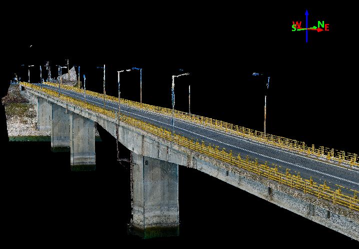
The digital twin of the Lake Polyfytos Bridge was based on state-of the art photogrammetry methods. For the extended survey and the construction of the digital twin more than 1000 high resolution photos were taken per 100m along the length of the bridge, both nadir and oblique in various angles in fully automated missions. Additionally, another 10 ground control points and check points per 100m were defined, for improving the accuracy and consistency of the acquired data. Also, surveying measurements of the structure were taken by making use monitoring-grade total station and high-precision multi-hour static GNSS measurements of its’ stationary points. All photographs, in raw format, were initially processed through photo-editing software for enhancement and then used in photogrammetry software. The point cloud generated has a point-to-point spacing of 7mm and is being used for assessing the current condition and monitor potential evolution of deterioration and structural defects. The most critical structural components of the bridge is currently measured with a laser scanner. The survey was conducted by Yannis Karnaris, Surveying and Geomatics Engineer, PhD in Drone Photogrammetry
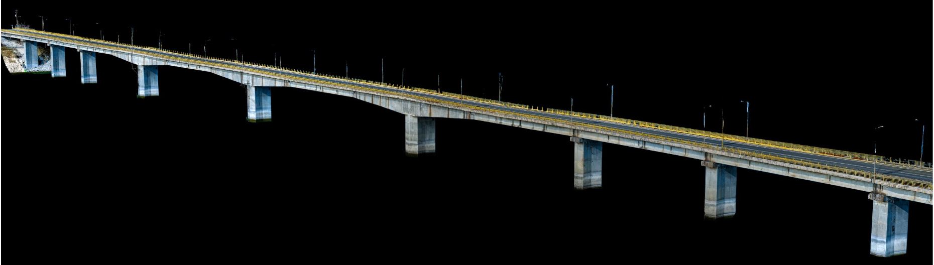
the digital twin of the bridge
the digital twin of the bridge – another view
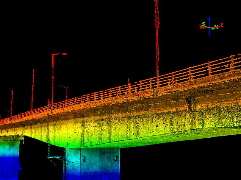
digital twin of the bridge – different colours indicate different elevation
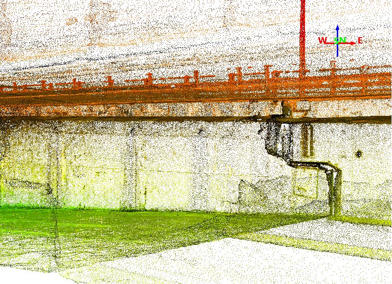
detail of the digital twin – hald joint
Multitemporal SAR interferometry and engineering evidence
.
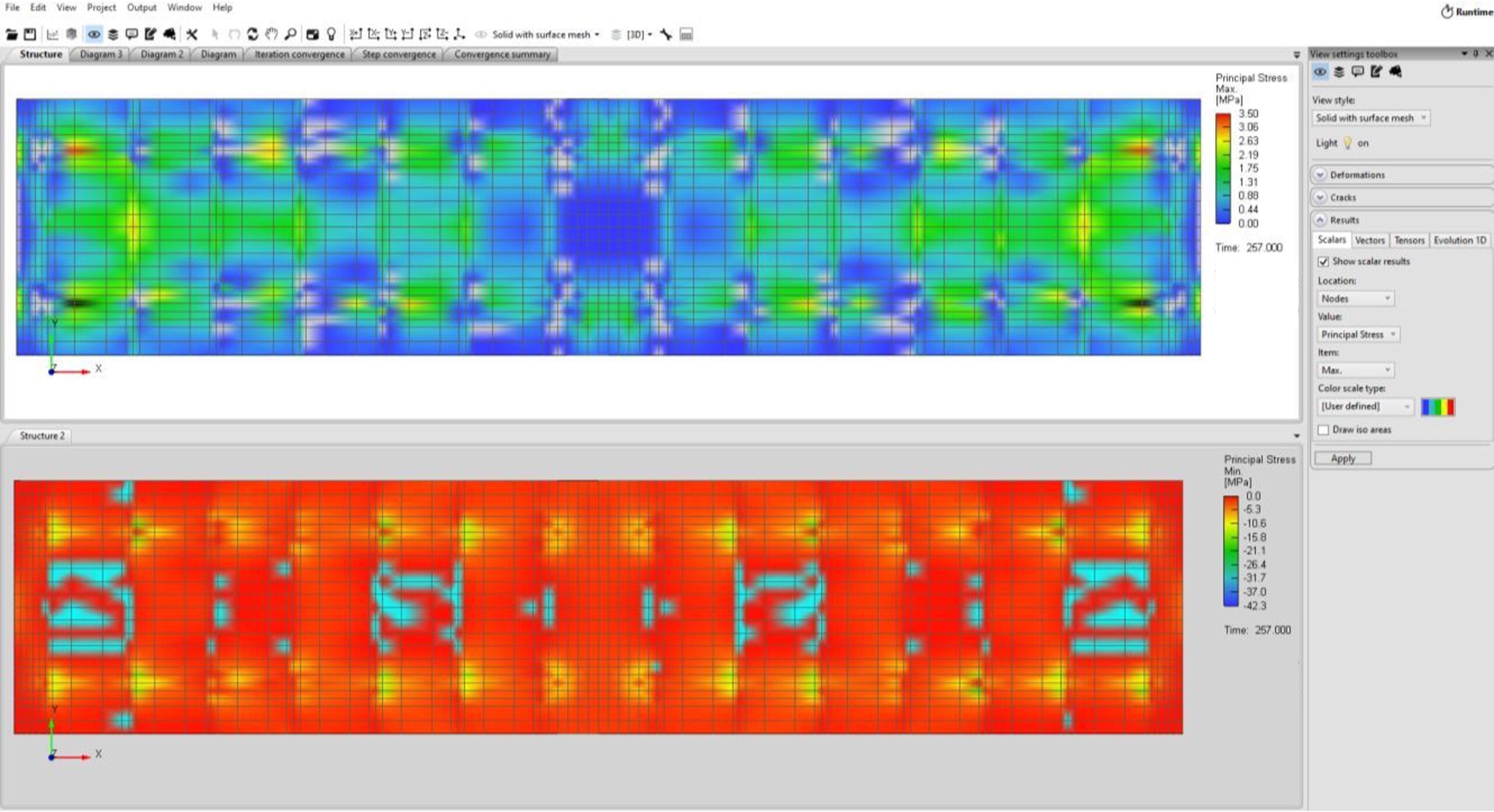
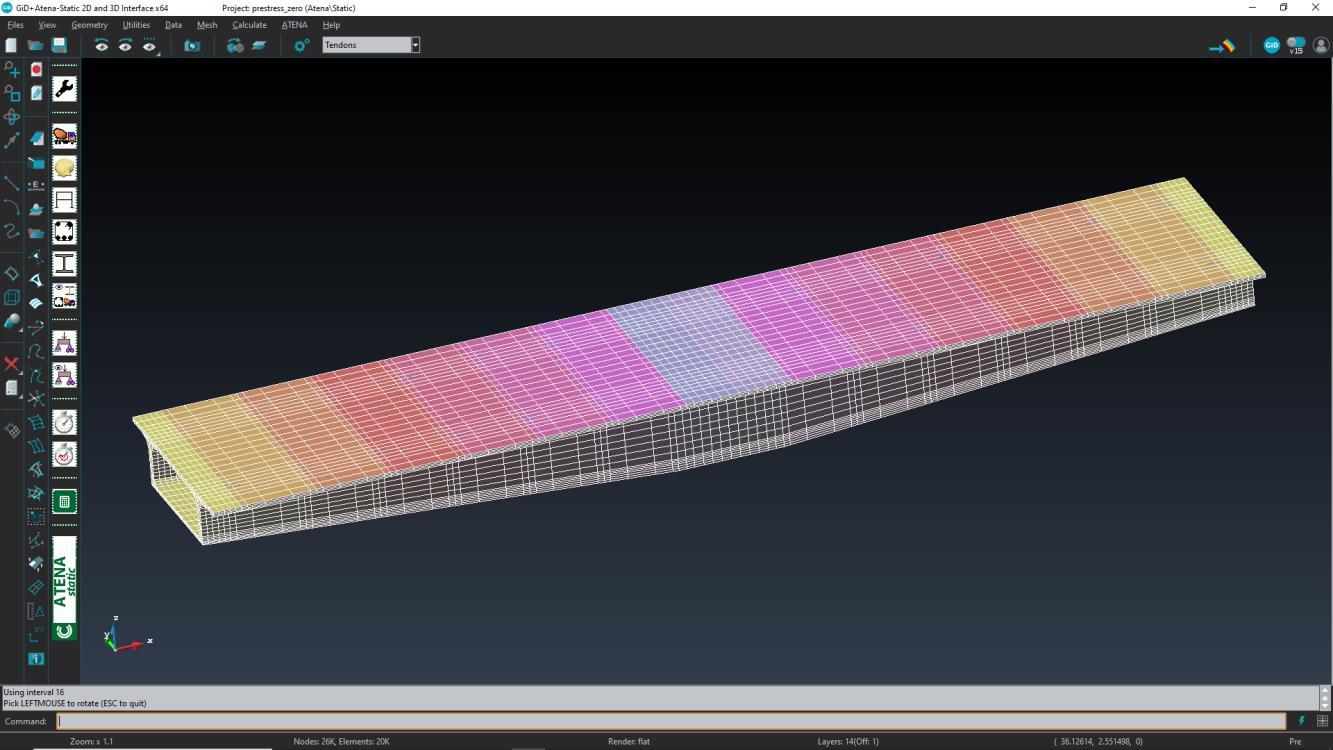
Advanced numerical modelling
.
Scenario-based model updating for matching digital data with observed responses [5] [6].
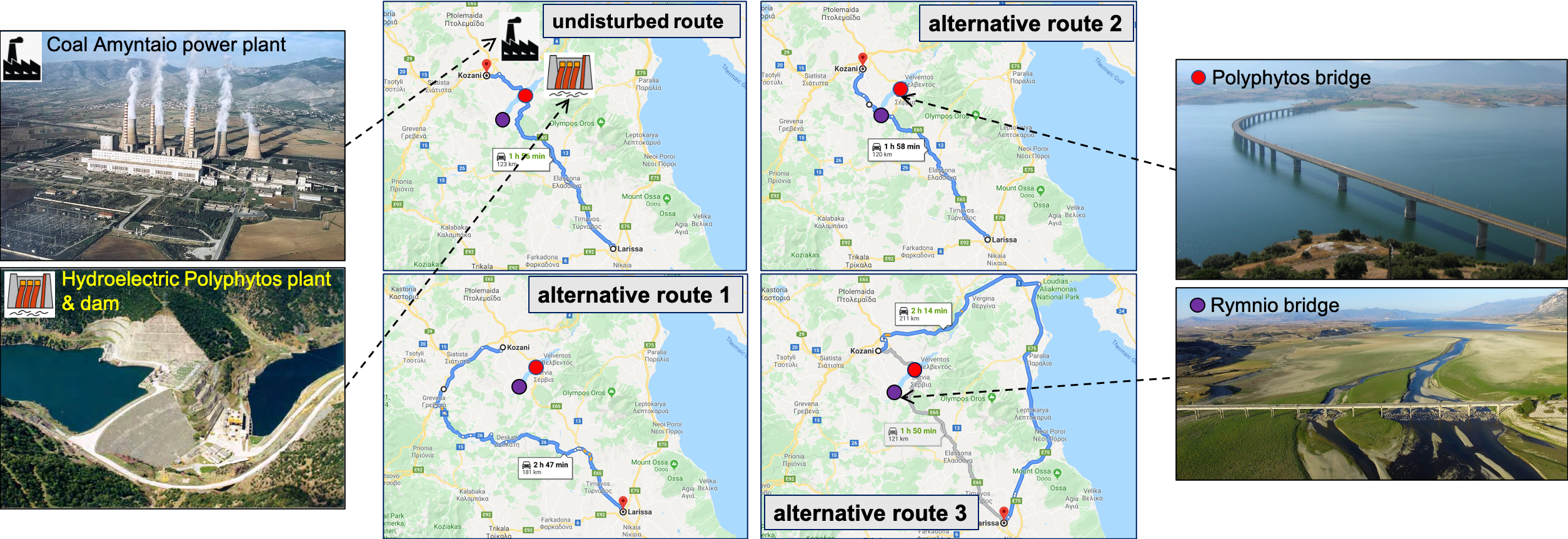
Interdependencies with power stations and other critical assets
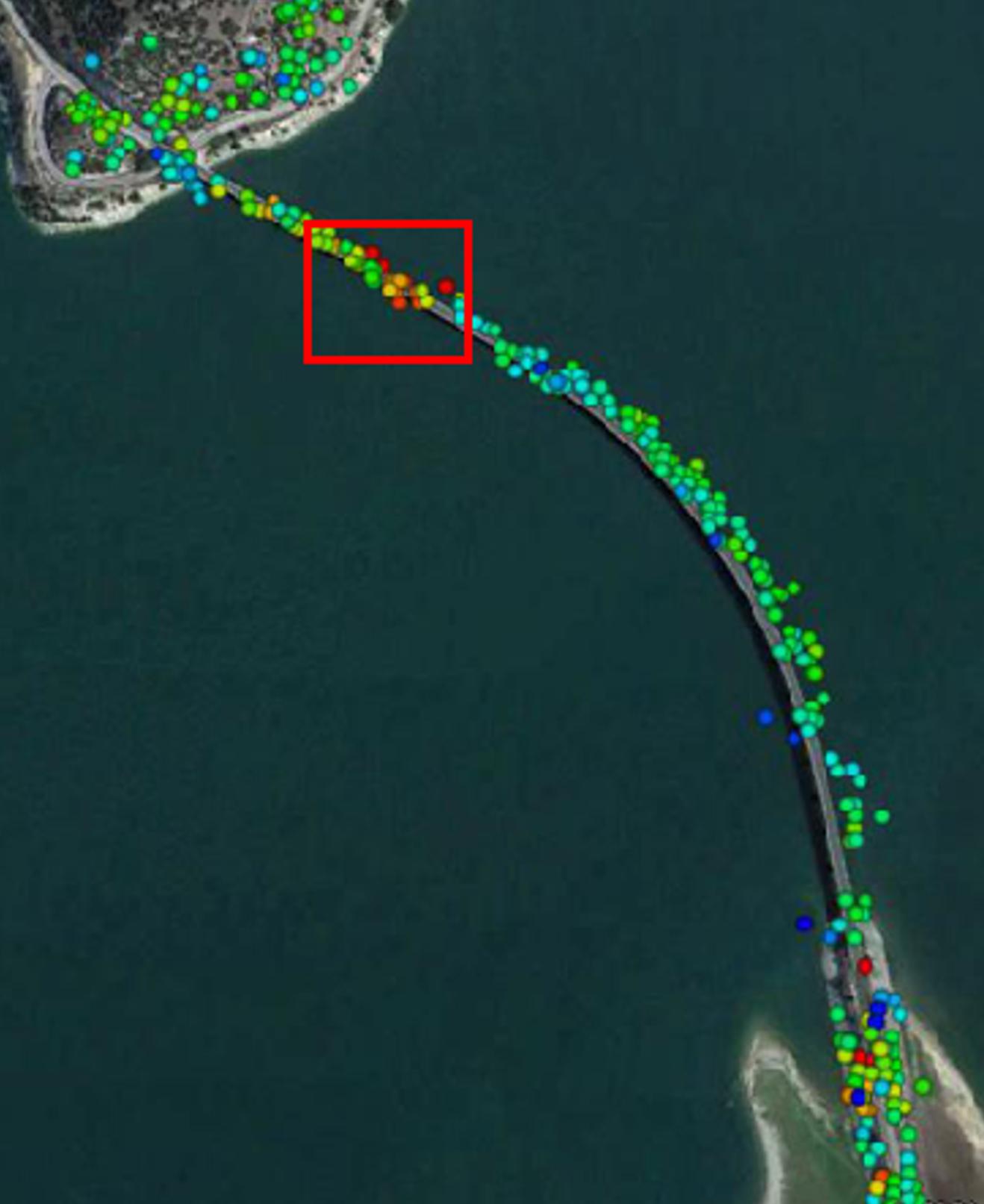
The picture below shows the area of interest with emphasis on the interoperabilities between critical transport and energy assets/infrastructure, and the impact of bridge closure to the connectivity and travel time between major cities in the vicinity of the lake. The four critical assets are the lake Polyfytos bridge, the Rymnio bridge, and two major power stations, the Amyntaio power plant (600MW) and the Polyfytos hydroelectric facility (420GWH per year).
Use Case 2: Resilience-based post-disaster infrastructure recovery prioritisation
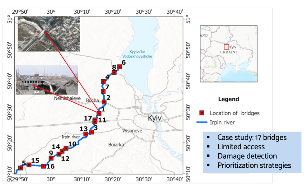
Use Case 3: Sustainability and resilience-driven prioritisation for restoring critical infrastructure after major disasters and conflict
prioritisation; resilience; sustainability; conflict-induced hazards; bridges; proactive and reactive measures. Kopiika, N., Di Bari, R., Argyroudis, S., Ninic, J., & Mitoulis, S. A
Sustainability and resilience-driven prioritisation for restoring critical infrastructure after major disasters and conflict.
Method
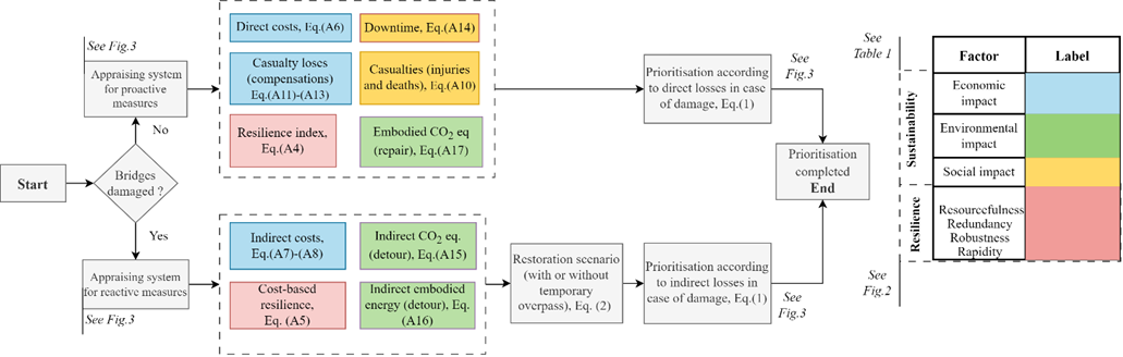
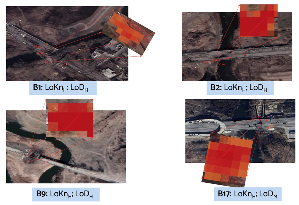
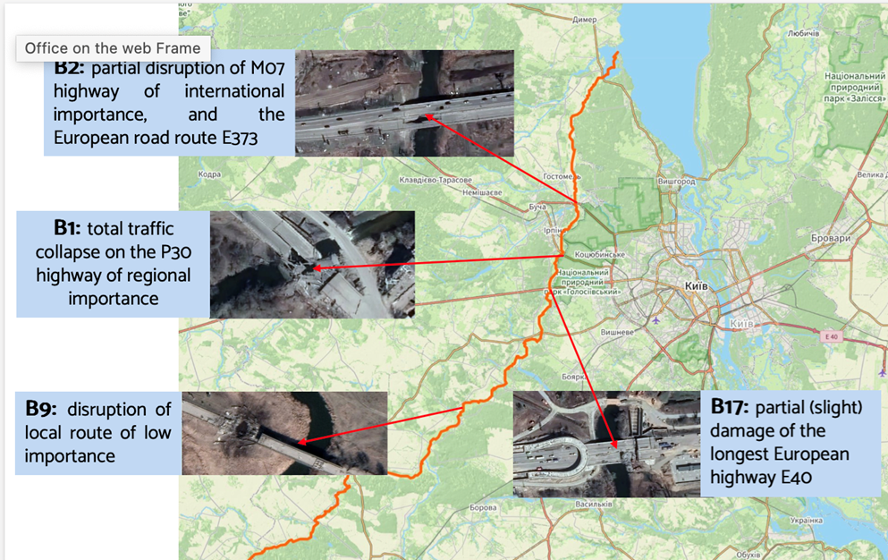
Case study
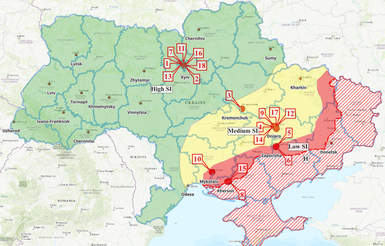
Results

See publications:
- Argyroudis S, Mitoulis SA, Chatzi E, Baker JW, Brilakis I, Gkoumas K, Vousdoukas M, Hynes W, Carluccio S, Keou O, Frangopol DM, Linkov I (2022). Digital technologies can enhance climate resilience of critical infrastructure. Climate Risk Management, 35, 100387 https://doi.org/10.1016/j.crm.2021.100387
- Achillopoulou DV, Mitoulis SA, Argyroudis S, Wang Y (2020). Monitoring of transport infrastructure exposed to multiple hazards: A roadmap for building resilience. Science of the Total Environment, 746, 141001.
- Argyroudis S, Mitoulis SA, Hofer L, Zanini MA, Tubaldi E, Frangopol DM (2020). Resilience assessment framework for critical infrastructure in a multi-hazard environment. Science of the Total Environment, 714, 136854.
- Markogiannaki O, Chen F, Xu H, Mitoulis SA, Parcharidis I (2022). Monitoring of a landmark bridge using SAR Interferometry coupled with engineering data and forensics, International Journal of Remote Sensing. 43(1):95-119 https://doi.org/10.1080/01431161.2021.2003468
- Moutsianos S (2020) Serbia High Bridge 3D Nonlinear Analysis of the balanced cantilever construction stages and prestressing loss scenarios, Dissertation Thesis, Supervised by Dr V Papanikolaou, Aristoteleion University of Thessaloniki.
- Moutsianos S (2021) Bridge finite element model calibration by integrating data from digital twin, in-situ inspections and expert elicitation, MSc Dissertation Thesis, Supervised by Dr S Mitoulis.
- Smith A, Argyroudis S, Winter MG, Mitoulis SA (2021). Economic impact of road bridge functionality loss from a resilience perspective. ICE Bridge Engineering, https://doi.org/10.1680/jbren.20.00041
- Argyroudis S, Nasiopoulos G, Mantadakis N, Mitoulis SA (2020). Cost-based resilience assessment of bridges subjected to earthquakes. International Journal of Disaster Resilience in the Built Environment, DOI 10.1108/IJDRBE-02-2020-0014.
- Kopiika, N., Karavias, A., Krassakis, P., Ye, Z., Ninic, J., Shakhovska, N., Argyroudis S., Mitoulis, S. A. (2025). Rapid post-disaster infrastructure damage characterisation using remote sensing and deep learning technologies: A tiered approach. Automation in Construction, 170, 105955.
- Mitoulis, S. A., Argyroudis, S., Panteli, M., Fuggini, C., Valkaniotis, S., Hynes, W., & Linkov, I. (2023). Conflict-resilience framework for critical infrastructure peacebuilding. Sustainable Cities and Society, 91, 104405. https://doi.org/10.1016/j.scs.2023.104405
- Kopiika, N., Di Bari, R., Argyroudis, S., Ninic, J., & Mitoulis, S. (2025). Sustainability and resilience-driven prioritisation for restoring critical infrastructure after major disasters and conflict. Transportation Research Part D: Transport and Environment, Article 104592. Advance online publication. https://doi.org/10.1016/j.trd.2025.104592