Resilience, Sustainability & Digitalisation in Critical Infrastructure
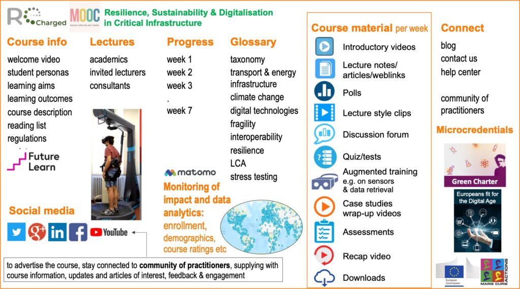
This Massive Open Online Course (MOOC) is a free, open, online course designed to offer a taste of higher education to learners from across the world. The University of Birmingham is delivering new MOOCs in partnership with FutureLearn. Delivered by world-class academics from the University of Birmingham and other partners of the HORIZON Recharged project (GA no. 101086413), the course enable learners worldwide to sample high-quality academic content via an interactive web-based platform from leading global universities, increasing access to higher education for a whole new cohort of learners.
The course is developed by senior academic staff and their content is reviewed regularly, taking into account student feedback.
This MOOC brings together world experts, including general audiences, aiming to provide training with life-long updates and professional development opportunities for general and specialised audiences. The MOOC contains all the necessary components of a university taught module, e.g. prerequisites, content and aims, learning outcomes, attributes for sustainable professional development (cognitive, analytical, transferable skills, professional and practical skills), expected hours of study, assessment patterns, units of assessment and reading list, warm-up sessions, with relevant podcasts and videos, lecture notes and recorded lectures, some of which will be tailored for general audiences. This open course will be available on futurelearn.com and on the project website.
These lecture notes are accompanying the seven lectures of the MOOC. Following is the MOOC description, which contains the outcomes, the aims per week and the learning activities. The latter include a combination of material acquisitions and discussions, investigations and production, practical examples and analysis of case studies, and a set of collaboration and discussion forum.


INTRODUCTION
Point cloud generation:
The value of emerging technologies in climate resilience and sustainability of infrastructure.
Emerging and disruptive digital technologies have the potential to enhance climate resilience of critical infrastructure, by providing rapid and accurate assessment of asset condition and support decision-making and adaptation. Such emerging digital technologies include Internet of Things, digital twins, Artificial Intelligence which can be placed at the service of engineers to design more sustainable and resilient structures.
What is a point cloud and why we need them in infrastructure management?
Point clouds hold rich spatial data for comprehending and managing infrastructure assets, e.g., bridges. They offer precise, detailed structural representations, capturing geometry and are valuable in creating digital twins, which mirror real-world structures. Point clouds and digital twins act as indistinguishable digital counterparts, facilitating simulation, testing, monitoring, and adaptation to stressors like climate change.
What is a point cloud and why we need them in infrastructure management? Point clouds offer a wealth of spatial information that helps in understanding, analyzing, and managing infrastructure assets, like bridges. Point clouds provide a highly accurate and detailed representation of the structure. They capture the geometry. They are very useful in generating digital twins, which are digital representations of an actual real-world physical structure. Point clouds and digital twins serve as the effectively indistinguishable digital counterpart of a structure for practical purposes, such as simulation, testing, monitoring, and adaptation to new stressors, such as climate change.
Main steps for the development of the point cloud.
To generate a point cloud for a bridge that you see behind me you would typically follow a number of steps:
1. Data capture planning: First we need to determine the appropriate data capture method based on the size, complexity, and accessibility of the bridge. Common methods include airborne, mobile, or terrestrial LiDAR. The selection should consider factors like resolution requirements & accuracy depending on the purpose of the point cloud.
2. Data acquisition: We then use the chosen data capture method to collect the necessary data. For example, if we use a terrestrial LiDAR, that requires setting up stationary scanners and capturing data from multiple viewpoints to cover all sizes of the bridge-that will lead us to millions after millions of points each one of which has a unique set of coordinates.
3. Reference Points: Thus, we also need a coordinate system and reference points. These reference points serve as common origin or baseline for all the points captured in the cloud. Commonly we use as reference points global positioning system (GPS) coordinates or survey control points.
Weather Conditions: Weather significantly affects point cloud data quality and reliability, notably especially in remote sensing tech like LiDAR (Light Detection and Ranging). Sunlight causes shadows, impacting accuracy. Lighting conditions should be carefully considered when planning data collection. Additionally, motion artifacts can result from traffic and passersby. Hence, data from multiple sources, viewpoints, and time instances must be combined.

LECTURES
What is this MOOC about?
This week introduces the concept of resilience and how it is important for systems and organizations to withstand and adapt to challenges.
- Activity 1. What is Resilience?
- Activity 2. What is Sustainability?
- Activity 3. What is Digitalisation?
Now that we have completed with the introduction, in the next step we will explore how hazards are classified, how damages and losses are assessed based on fragility functions and how risk is analysed, including the production of risk metrics.
How can we quantify risk and how risk-based infrastructure management is put into practice?
The aim of this week is to introduce the concepts of vulnerability and risk for critical infrastructure subjected to climate hazards. This includes the classification and characterisation of natural hazards, identification of hazard exacerbations due to climate change, and the definition of fragility and vulnerability models for critical infrastructure. Week 2 will also present applications for representative transport and energy assets and systems which may also suffer from ageing and other natural and human induced stressors.
- Activity 1. Natural Hazards and climate projections
- Activity 2. Fragility and vulnerability
- Activity 3. Risk analysis
After having introduced the quantification of risk and losses for multiple hazards based on fragility models, in lecture 3 we will see in more detail what is resilience and how resilience metrics can help us make decisions for more robust infrastructure developments and infrastructure systems management.
What is the value of resilience? How can we measure resilience in critical infrastructure management?
The aim of this week is to introduce the concept and properties of resilience for critical infrastructure, including quantification of resilience based on metrics for decision making. This week also includes definition of restoration and reinstatement models considering available resources, level of damage and type of infrastructure assets. The concepts of proactive (ex-ante / by design) and reactive (ex-post/ by intervention) resilience will be presented based on case studies for critical assets. Resilience by assessment will be discussed as a capability in case of inaccessible assets.
- Activity 1. Restoration and reinstatement models
- Activity 2. Proactive and reactive restoration
- Activity 3. Resilience metrics
Now that we have explored the notion of resilience and its metrics, in lecture 4 we will do the same for sustainability with a focus on infrastructure management. In the next lecture we are discussing LCA and circularity in infrastructure development.
What is sustainability and circularity in the context of critical infrastructure management and how does it influence our decisions?
The aim of this week is to introduce the concept and properties of resilience for critical infrastructure, including quantification of resilience based on metrics for decision making. This week also includes definition of restoration and reinstatement models considering available resources, level of damage and type of infrastructure assets. The concepts of proactive (ex-ante / by design) and reactive (ex-post/ by intervention) resilience will be presented based on case studies for critical assets. Resilience by assessment will be discussed as a capability in case of inaccessible assets.
- Activity 1. Introduction / Circularity
- Activity 2. Life-cycle assessments (LCA)
- Activity 3. Carbon emissions assessments and metrics
- Case study on critical infrastructure
Having by now explored baseline resilience and sustainability models for infrastructure management, in lecture 5 you will be introduced to digital technologies and how the power of computer science and data can facilitate infrastructure development, inspection and maintenance.
Which are the main digital technologies and what is the type of data that we obtain from them to make decisions for our critical infrastructure more effectively?
The aim of this week is to explore digital technologies’ impact on infrastructure monitoring, covering data acquisition, processing, and modelling. Key objectives include understanding digitalization’s influence on infrastructure lifecycle, categorizing technologies by application scope, examining remote sensing methods for data collection, and addressing challenges in assessing structural conditions through acquired data.
- Activity 1. Types of technologies, disparate source and types of data
- Activity 2. Machine learning and computer vision
- Activity 3: Building information modelling and digital twins
We have so far collected, analysed and applied metrics of risk, resilience and sustainability. Next, we discuss the optimisation of these philosophies, which might be positively or negatively correlated in infrastructure management.
What are the main methods to tackle uncertainty and optimise competing metrics of resilience and sustainability?
The aim of this week is to introduce optimisation of resilience and sustainability for critical infrastructure, including Multi-Criteria Decision-Making (MCDA) and Pareto fronts, in infrastructure management. Optimization paths will be used, revealing trade-offs and Monte Carlo approaches will be taught to enhance precision. Social factors in holistic decision-making will be introduced. A case study will be illustrated to understand how optimizing a critical climate-sensitive infrastructure underscores the synergy between MCDA, Pareto fronts, and Monte Carlo simulations, yielding robust solutions that balance environmental, economic, and social dimensions.
- Activity 1. Methods of optimisation and trade-offs in infrastructure management
- Activity 2. Impacts and consequences analysis
- Activity 3. Case study on a critical infrastructure
We live in a very uncertain world, where climate change, urbanisation, cyber attacks and other threats and stressors burden our ageing infrastructure. To harness uncertainty in lecture 7 we will introduce you to stress-testing which can be used in threat aware and threat agnostic scenarios. Nature based solutions are also introduced as the way forward for more inclusive and eco-friendly climate adaptation strategies in critical infrastructure.
How stress-testing can be used to better understand the impact of climate change on our infrastructure? What are the benefits of environmentally friendly and nature-based solutions?
The aim of this week is to introduce adaptation strategies for climate change projections in critical infrastructure sector. Through a combination of theoretical knowledge and practical applications, students will learn how to stress-test infrastructure systems, implement proactive and reactive adaptation measures, and evaluate the impact of these actions on greenhouse gas emissions for different climate scenarios. This week will delve into innovative strategies such as Nature Based Solutions, providing students with tools to enhance infrastructure’s capacity to withstand shocks and adapt to changing environments. Focusing on transport assets, students will engage in real-world comparisons, ensuring they can make informed decisions for creating robust and sustainable infrastructure systems in the face of complex challenges.
- Activity 1. Proactive and reactive adaptation measures
- Activity 2. Nature Based Solutions
- Activity 3. Resilience and sustainability stress-testing